Tewksbury, MA
Delivered on October 7, 2022, the results arrived in weeks instead of months, shrinking the time between inspection and construction so residents saw improvements faster.
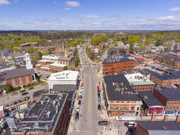
Tewksbury, MA Infrastructure Assessment
Summary
- Citywide pavement intelligence delivered in weeks, enabling faster repairs for residents
- 143 roadway miles scanned and scored, giving leaders clear, defensible paving plans
- Transparent reports calmed 311 calls and town meetings, restoring public trust
Problem
Tewksbury’s pavement program was slowed by outdated and inconsistent condition data, making it hard to know which roads to fix and when. Staff were stuck playing defense to resident complaints without a clear, defensible prioritization method to explain at council and community meetings. Budget planning was difficult to justify because estimates relied on guesswork instead of a current, measurable view of network needs.
Solution
Tewksbury selected Cyvl to modernize its roadway assessment using vehicle-mounted LiDAR and sensors to rapidly survey the city’s streets. Cyvl’s Infrastructure Intelligence platform used AI to convert the field data into detailed, actionable pavement condition scores, prioritized repair lists, and ready-to-share reports for leadership and residents. In total, 143 roadway miles were scanned and analyzed, unlocking a defensible multi-year plan with project-level quantities the city could act on immediately.
Impact
Delivered on October 7, 2022, the results arrived in weeks instead of months, shrinking the time between inspection and construction so residents saw improvements faster. With citywide condition scores and quantities, Tewksbury produced clear, transparent paving programs that aligned engineering needs with taxpayer value. The new data made it easier to communicate choices, secure funding, and schedule work so crews could fix the right roads at the right time.
- 143 roadway miles scanned with LiDAR and sensors, producing citywide condition scores and prioritized repair lists
- Faster fixes for residents as crews received ready-to-build work packages weeks after data collection
- Fewer 311 complaints and smoother town meetings because decisions are backed by transparent, map-based reports
- More accurate budgets and easier funding approvals through quantified needs, unit costs, and multi-year scenarios
- Safer driving with earlier identification of hazards and more proactive maintenance cycles
- Easier planning: budget allocation, public communication, and crew scheduling now align to clear data


-%20logo%20(unpadded).png.png)