Rensselaer, IN
The city moved from reactive to proactive the moment the dataset arrived on November 27, 2023, compressing months of fieldwork and analysis into information leaders could act on immediately.
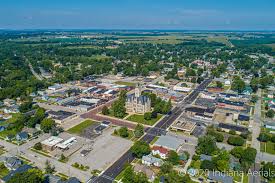
Rensselaer, IN Infrastructure Assessment
Summary
- 43 roadway miles scanned with LiDAR in weeks, giving Rensselaer a current, comprehensive view of street conditions that speeds visible repairs for residents
- 1,774 traffic signs inventoried to improve safety and prioritize replacements residents notice on daily routes
- Data-driven maintenance plan delivered by November 27, 2023, enabling faster project starts and more efficient use of taxpayer dollars
Problem
Rensselaer was working with outdated and inconsistent road information, so leaders didn’t know which streets to fix or when, and paving budgets were hard to defend. Without clear data, staff were stuck playing defense to resident complaints—answering “Why not my road?” in meetings and fielding a steady stream of 311 calls and emails. This reactive posture slowed maintenance decisions and extended the time residents waited for safer, smoother streets.
Solution
Rensselaer chose Cyvl to rapidly survey the entire network using vehicle-mounted LiDAR and sensors, scanning 43 roadway miles and capturing detailed surface condition data along with an inventory of 1,774 signs. Cyvl’s Infrastructure Intelligence platform used AI to transform this data into condition scores, prioritized repair lists, and defensible maintenance plans the city could stand behind. Delivered in weeks by November 27, 2023, the city received detailed, actionable pavement condition data and clear reports to build a comprehensive plan quickly and communicate the path forward to residents.
Impact
The city moved from reactive to proactive the moment the dataset arrived on November 27, 2023, compressing months of fieldwork and analysis into information leaders could act on immediately. With block-by-block condition scores across 43 miles and a verified inventory of 1,774 signs, crews can sequence work logically, fix issues faster, and show residents what’s next and why. Data-backed plans improved budget defense, scheduling, and public communication, so projects start sooner and are coordinated around community needs.
- 43 roadway miles scanned with LiDAR sensors, enabling targeted maintenance where residents drive, bike, and walk every day
- 1,774 signs inventoried to prioritize replacements and upgrades that improve safety at crossings, neighborhoods, and school zones
- Weeks-not-months delivery accelerated project kickoff, reducing the time between data collection and pavement repairs
- Fewer 311 complaints and smoother town meetings because priorities are transparent, mapped, and backed by objective condition scores
- Stronger budget defense and faster approvals as leaders can show efficient use of taxpayer dollars with clear, defensible plans
- Streamlined scheduling and crew routing with prioritized work lists and GIS layers that make communication to residents timely and accurate


-%20logo%20(unpadded).png.png)