Haverhill, MA
By June 7, 2022, Haverhill had a complete, data-rich view of all 231 roadway miles, including detailed, actionable pavement condition data for every segment.
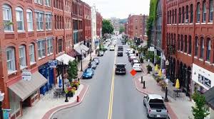
Haverhill, MA Infrastructure Assessment
Summary
- 231 roadway miles scanned with LiDAR and sensors, delivered in weeks by June 7, 2022, accelerating street improvements residents could see
- Actionable pavement condition scores and prioritized repair lists gave Haverhill a defensible, transparent paving plan
- Data-driven budgeting and scheduling improved speed to fix streets and increased the value of every taxpayer dollar
Problem
Before 2022, Haverhill relied on outdated and inconsistent pavement information, making it hard to know which roads to fix or when and difficult to defend paving budgets. Public works often played defense in town meetings, facing constant “Why not my road?” questions and a flood of 311 emails without shared facts to justify choices. With limited staff time and partial data, the city was stuck reacting to complaints instead of following a citywide plan residents could understand and trust.
Solution
Haverhill chose Cyvl to rapidly survey its entire street network, using vehicle-mounted LiDAR and sensors to capture high-resolution conditions across 231 roadway miles. Within weeks, Cyvl’s Infrastructure Intelligence platform used AI to convert the scans into detailed pavement condition scores, documented distresses, GIS layers, and prioritized repair lists that supported scenario-based, defensible work plans. Clear reports and maps were delivered by June 7, 2022, giving leaders accurate, network-wide data to act faster and communicate decisions with confidence.
Impact
By June 7, 2022, Haverhill had a complete, data-rich view of all 231 roadway miles, including detailed, actionable pavement condition data for every segment. Because delivery happened in weeks rather than months, crews could be scheduled sooner, shrinking the time between data collection and visible street improvements. Leaders used transparent condition scores and ranked project lists to align budgets, justify choices in public meetings, and target the highest-impact segments first.
- 231 roadway miles scanned with LiDAR delivered precise condition scores so the right streets get fixed first and residents see faster results
- Final data and reports delivered on June 7, 2022 enabled construction-season decisions in weeks, accelerating paving and patching programs
- Faster, defensible planning reduced 311 complaints and “Why not my road?” conflicts by showing clear, map-based priorities
- Budget allocation, public communication, and work scheduling became easier with transparent data, improving the value of every taxpayer dollar
- Crews addressed high-impact repairs sooner, improving safety, reducing flat tires, and smoothing daily commutes
- Public works earned greater confidence from the council and residents with a plan backed by auditable data and repeatable methods


-%20logo%20(unpadded).png.png)